Insights > Entergy Arkansas Adds High-Tech Drone to Toolbox
Entergy Arkansas Adds High-Tech Drone to Toolbox
11/20/2017

We’re still waiting for flying cars, but Entergy Arkansas has acquired the next-best thing: a drone.
Admittedly, among amateur hobbyists, drones these days are a dime a dozen. But this is no hum-drum drone. We’re talking four 17-inch propellers, 38 minutes of flying time, high-resolution cameras for stills and video, built-in ability to keep itself from flying into trees and tall buildings, and a whole lot more.
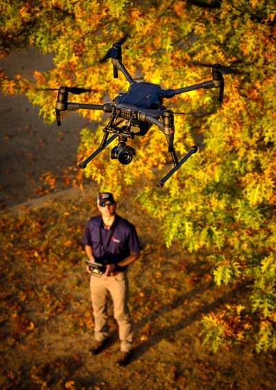
And while the drone sports lots of on-board automation, it does require a pilot.
Meet Eric Treadwell. A photography and aviation enthusiast, Treadwell is an Entergy Arkansas Geographic Information System database analyst. This job has him earthbound in front of his computer most of the time. But he has higher aspirations. He’s the one person authorized to fly the Entergy Arkansas drone.
Treadwell was a US Army air traffic controller. With 20 years of GIS experience behind him, he joined Entergy in 2014.
On his own initiative, Treadwell recently completed the FAA certification process to fly drones for commercial purposes, meaning he’s now legal to fly for Entergy.
Talented photographers are not uncommon. FAA-certified drone pilots are more scarce, but they’re out there. But one person who’s both a skilled photographer and certified drone pilot? A rare bird, indeed.
“We’ve hired contract drone pilots several times in the past,” said Audie Foret, operations and safety manager. “This is something we thought we could do better and at a lower cost by bringing it in-house.”
Among the uses envisioned for the Entergy Arkansas drone:
- Helping scout hard-to-reach storm-damaged areas. The drone must remain in line-of-sight of the pilot, but put a drone 200 feet above a catastrophe, and it can instantly see what would take ground-based scouts many hours cover. Faster scouting means faster restoration. Soon the drone will have the capability to transmit live video to a command center in Little Rock. “A huge bonus,” Foret said, “is that we can scout hard-to-reach storm-damaged areas much more safely with this drone without exposing any employees to downed power lines or unknown hazards.”
- Inspecting circuits. Entergy has long used manned helicopters to patrol transmission lines. That practice will continue, since they can cover hundreds of miles in hours. However, for close-up spot checks of distribution overhead equipment, before drones, one would have to either climb a pole or ride up in a bucket. The drone presents a third option.
- Infrared inspection. In 2018, plans are to add an infrared camera to the drone so it can look for hot spots on components. Hot spots indicate impending failure. With that information, Entergy employees can do a better job of fixing problems before they cause outages.
- Demolitions. In the past, Entergy Arkansas had hired drone pilots to document the explosive demolitions of the retired power plants. Future demolitions can be shot with the Entergy Arkansas drone.
- Customer and employee communications. Photos and video are important tools for sharing information with customers and employees. The drone will be instrumental in enhancing visual communications. Examples include documenting storm damage, solar projects and aerial views of company facilities.
“We’re the first Entergy operating company to invest in a drone, and we’re looking forward to demonstrating its capabilities,” added Foret. “Now that we own the equipment and we already have a pilot on the payroll, we can really explore the possibilities. The sky’s the limit!”